Introduction
The Hor al Azim or Howeyzeh marshlands are a network of wetlands straddling the Ahwaz-Iraq border, which are fed by two branches of the Tigris River, the Euphrates in Iraq, and the Karkheh River in Ahwaz. On the Ahwaz side, the marshlands are located between the two main rivers in Ahwaz where the exceptional nature of the unique ecosystem has been acknowledged globally (Mehr news agency, 2015). These rare, once-lush waterways are located in the midst of vast arid and semi-arid zones, attracting massive numbers of migratory birds, as well as hosting a sizeable year-round avian population (Tasnim News Agency, 2018). These mudflats, which are also home to a diverse range of plant life, including sugar cane, also once teemed with aquatic life, including a number of species facing extinction such as Euphrates soft-shell turtles that are threatened by waterway pollution and habitat destruction and illegal hunting by fishermen and Chinese workers who work in the oilfields located in the heart of the marshlands (Trend News, 2014) & (researchgate, 2008).
The fish from this area are renowned across the region, with generations of farmers and fishermen making a living in these waters. The reed beds are also used by local people for material for the crafts which the area is known for, including intricately decorated mats and baskets, as well as providing fodder for the buffaloes and other wild animals and livestock there. The papyrus reeds were also once used for manufacturing paper.
The tragedy that has befallen this once-bounteous region in recent years is vast and terrible in its scale, with the effects of environmental degradation resulting from massive pollution and damming of the rivers that fed the marshlands affecting every area of life, both human and aquatic, as well as devastating local wildlife and leaving the local people no option but to emigrate elsewhere for survival (Global Voice, 2018).
In this study, we shall look into the reasons behind the marshlands’ slow disappearance and their impact on various related issues.
Hor al Azim: Drought or desertification
The Karkheh River is the main source of feeding the marshland. Several smaller rivers branch off the main body of the Karkheh, including Bastin, Al-Sabla, Rofaye and Al-Hawfal. Data from satellite imagery, from 1973 to 2018, indicates that the area of the marshland shrank massively, losing almost two-thirds of its total area going from 311,642 hectares to proximately 130,133 hectares in a 45-year period (Borwall, 2017).
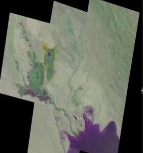
The question is: Who is primarily responsible for the shrinking area of the marshland? Is it human intervention or natural decline?
The rainfall records in the period from 1991 to the present indicate that in most of the years covered, the amounts of rain pouring into the Karkheh River basin from upstream have actually risen year on year (Tasnim News Agency, 2018). This underlines that the shrinking of the marshlands is not caused by any shortage of rainfall or another natural phenomenon, making it quite certain that manmade phenomena are behind the gradual desertification of the historic marshlands (Donya-e-Eqtesad newspaper, 2017) & (BBC Persian, 2012).
One primary reason behind this tragic loss is the construction of two major dams on the rivers that once fed the marshlands; the Ataturk dam in Turkey and the Karkheh dam in Ahwaz. Another major contributory factor has been the pollution from oil and gas fields that are blighted the area since the discovery of the Azadgan, Yaranand Yadavarn oilfields in the middle of the Marshlands of Hor al Azim. These two factors have not only cut off much of the water supply that previously fed the area, but have also poisoned much of the remaining greatly reduced water supply, leading to toxic aridity ( Irannews24, 2017).
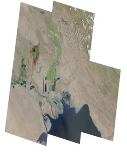
The impacts of the marshlands’ drying up and the pollution of the remaining waters are many and varied, also including desertification, dust storms, and a massive loss of all forms of wildlife and marine life. The effects on the area’s people have been equally devastating, bringing poverty as the sources of income are lost, disease due to the pollution and dust storms, and mass displacement as many are forced to flee their ancestral lands simply to survive. The rich civilisation and culture of the people of the marshlands area which date back millennia are being steadily driven into extinction, along with the fish, birds, animals and plant life (Middle East Monitor, 2017).
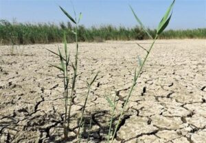
The gradual desertification has brought a massive increase in choking sandstorms which were once rare in the area. The air pollution levels exacerbate the damaging effects of these storms from the gas and oil refineries which mix with the sand with toxic particulates of oil and gas. The Iranian Meteorology Authority’s figures indicate that whilst the cause of these once-rare sandstorms was formerly largely attributable to weather patterns in other areas of the region, with only 10 per cent of the source attributable to domestic factors, this has risen sharply in recent years, with the period between 2005 and 2018 seeing a steep increase in domestic pollutants as oil and gas drilling in the region increased (Tasnim News, 2017).
A study on the domestic causes of the sandstorm led to seven areas in Ahwaz being identified as the worst affected. Two of these areas are located in southern Howeyzeh and northern Muhammara. Studying the satellite imagery, during the period as mentioned earlier from 1973 to 2018, indicates that the now-largely arid areas of southern Howeyzeh and northern Muhammarah were once also marshlands.
The soil in these areas is largely composed of clay and fine sediment. In the absence of the previous marshlands, winds pick up this sediment, causing sandstorms (Isna, 2015).
From the satellite images, we can clearly see how these areas of once-lush marshland have changed to being largely arid interspersed with areas of swamp. These sandstorms which have increased in frequency as the waters dried up have also transferred this barren soil and sand to other areas, in a cycle of aridity that accelerates the rate of desertification. Whilst the World Health Organisation sets the maximum air density fit for human habitation at 150 micrograms of sand or other particulates per cubic meter, the air density in these areas has risen in recent years to 9,991 micrograms per cubic metre, a level that often makes the air virtually unbreathable, and which is lethally dangerous for Ahwazis, particularly vulnerable groups like children or the elderly. This has led to high rates of illness, respiratory ailments and disease amongst the local people, while the droughts, pollution and massively reduced water flow mean that what water remains in the local rivers is largely saline; when the riverbeds dry up, this salty sediment is picked up in the sandstorms, often landing in other drinking water sources (Tehran Times, 2017).
Chemical pollution and desertification
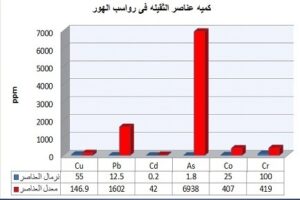
The land and plant life in and around the remaining marshlands are heavily polluted with different chemicals, mainly from the oil and gas fields and refineries, as well as from the runoff from sugarcane refineries built by the regime on rivers upstream. The chemicals found in tests on water and plant samples from the area include lead, copper arsenic, uranium, chromium, cadmium and cobalt, all of which are toxic to humans and other species at high levels. Whilst trace amounts of these chemicals aren’t harmful and are found in every substance, including food and drink, the degree of their concentration makes all the difference, with the level of these chemicals found in the marshlands area being far higher than the level deemed acceptable by the WHO. With arsenic, for example, the WHO sets the acceptable level for groundwater as 0.01 milligrams per litre. The global average for arsenic found in water is 1.8 mg per litre. Samples taken from the marshlands show that the arsenic level has reached a staggering 6,983 mg per litre (Iranian Journal of Fisheries Science, 2016).
As to copper, the WHO sets the acceptable level at 0.05 mg per litre of water. The average level globally average is 55 parts per million (ppm). In the Ahwaz marshland, this rises to a toxic 146 ppm. Again with lead, the WHO acceptable rate for water is 12.5 ppm. In the marshes, the samples tested had a lead level of 1,602ppm. The global rate of cadmium is 0.2 ppm; in the marshlands, it’s 42 ppm. With cobalt, the global rate is 25 ppm, in the marshlands, it is 407 ppm. The average global level of chromium in the water supply is 100 ppm; in the marshlands, it is as high as 419 ppm. Finally, the average rate of lethal uranium is 2.5 ppm; the sample in the marshlands was almost double that at 4.2 ppm.
As we see, the concentrations of these lethal chemicals in the marshland are far higher than the permitted global levels. These results demonstrate that the presence of these chemicals in the marshlands area is toxic to plant and animal life and to humans in the area. This is clearly not a natural phenomenon, but is instead the result of human activities, primarily oil and gas drilling and refining and heavy industry, though trace amounts can also be attributed to agriculture and to previous wars in the region.
Two figures are primarily used to represent the measurement of elements: Igeo (geo-accumulation index) and CF (Contamination Factors). When studying these two figures representing the deposits in the marshland, the root cause and rate of pollution in these areas s revealed. On the CF, figures show if this is below 1.5, it is clear that pollution is not caused by human interference. If it is above 1.5, however, this proves that human intervention is the primary factor.
The CF level found in the marshlands samples was consistently considerably over 1.5 in all plants, rising in some cases as high as 15. This high CF level undoubtedly demonstrates that the pollution in the marshes is wholly manmade.
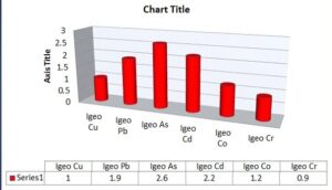
As to Igeo, if this factor is below zero, there is no pollution resulting from chemicals. But if this figure is above zero, this indicates the deposits are polluted due to large amounts of chemicals. Again, the Igeo level in the marshlands and neighbouring areas indicates that this factor is above zero in all samples from the area, rising as high as 3 in some of the plant samples. The presence of this element at this level indicates severe pollution.
The consistent high levels found in both the Igeo and CF measurements indicate alarmingly high pollution levels in the sediment, water and plant life of the marsh and neighbouring areas, including Howayzeh, Bastin, Khafajieh and Rofaye.
Pollution sources are divided into seven main categories, as follows: Sources of pollution resulting from sewage water, sources of pollution resulting from industrial, agricultural and medical waste, sources of pollution resulting from cleaning and refinery activities, sources of pollution resulting from military operations and war remnants, sources of pollution resulting from toxins used by fishermen, and sources of pollution resulting from oil and gas-related activities.
The increase in the levels of heavy chemicals present to far more than the globally permitted level has led to many diseases, illnesses and respiratory ailments among the residents of the marshlands area and the surrounding region, the most important of which are as follows:
The increase in the concentration of lead causes severe complications for human health, especially amongst newborn babies and young children, since the cumulative effects of lead in the human body damage the nervous system and cause anaemia due to the effect of lead in the blood-producing enzymes in the bone marrow.
If the rate of copper concentration exceeds the permissible limits, it gives water an undesirable metallic taste, as well as forming grease stains on furniture. Ingestion of high levels of copper from water or other sources leads to diarrhoea and vomiting. There is also a statistical relationship between heart disease and the percentage of copper in the blood. Exposure to levels of chromium exceeding the permissible limits leads to serious diseases such as kidney failure, liver disease, and lung cancer. Cobalt also increases the incidence of disease and leads to vomiting. High levels of cadmium also lead to serious diseases such as liver and kidney damage and high blood pressure.
Official figures
Sixty areas of wetlands in Iran, including nearly 44 per cent of the country’s total marshland areas, have dried up completely, according to the deputy head of the country’s Department of Environment (DOE) for Wetlands (radio Farda, 2018).
A number of senior officials have acknowledged that large areas of the country’s wetlands have been destroyed, with the Vice-President of the Department of Environment stating that 44 per cent of the country’s wetlands have dried up. While other areas of wetlands still remain, these are in a precarious, weakened state and face certain extinction unless action is taken to protect them.
“There are 1.3 million hectares, out of 1.5 million, which 105 wetlands are spread across; these are bearing the brunt of drought. This has led to the equivalent of 60 wetlands drying up,” Masoud Bagherzadeh said.
The director for environmental impact assessment at the DOE, Hamid Jalalvandi, said bluntly, “Once the Ilisu Dam is built, Hor al Azim, which has already been struggling with drought for years, will eventually drain away, causing a major environmental limbo in Ahwaz” (Tasnim news, 2017) & (Tabnak news, 2017).
The deputy environmental chief also noted that one of the most important issues in any effort to protect the wetlands or restore them to their former glory is the assignation of water rights. Sharing water in drought-stricken Iran, however, has become a bone of contention between residents of several neighbouring provinces and the Ahwaz region.
“Up to the mid-1990s, the water in the Hor al Azim wetland was as deep as ten metres, and the natural bushes that grew all around it were as high as 13 metres,” said Ahmad Sawari, a professor at Mohammed’s Science University in Ahwaz, adding, “But hectare after hectare of the wetland was given away for oil extraction. The destruction of these environments is unquestionably linked to the sandstorms” (Mehr news agency, 2015 b).
A former senior environmental official, Delavar Najafi Hajipour, also acknowledged in an interview with local media that the drying up of Hor al Azim was one of the causes of the sandstorms, with water being lost due to oil extraction around the wetland just after the Iranian regime’s 1980-88 war with Iraq (Mehr news agency, 2010)
Another official suggested that the Chinese firms that came to the country during the Ahmadinejad era to search for oil were among the reasons for the destruction of the wetlands.
He asserted that the inferior technology used by these firms in their drilling led to the destruction of the wetlands, saying, “To find oil, hectare after hectare of plant species around the Hor al Azim wetland were set ablaze or bulldozed” (Irna,2016).
Also, the decline of water levels in the wetlands deprived Ahwazi buffaloes of their prime source of food which is the green reeds and the other species of aquatic plants. These plants rid buffaloes of diseases, transmitted by insects like mosquitos, as they cough while in water (dialogue institute for research and studies,2018).
By Rahim Hamid, an Ahwazi author, freelance journalist and human rights advocate. Hamid tweets under @Samireza42.
References:
1: Mehr news agency. (2015, 18 May). Follow up of environmental activists for the global registration of Horalazim wetlands. Link: https://www.mehrnews.com/news/2582737/
2: Tasnim News Agency. (2018, 2 February). Horalamiz hosts seasonal migratory birds + photos. Link: https://www.tasnimnews.com/fa/news/1396/11/13/1644901/
3: Trend News Agency. (2014, 4 February). Chinese workers illegally hunt and eat rare turtle species in Iran. Link: https://en.trend.az/iran/2238029.html
4: Researchgate. ( 2008, December). Conservation Status of the Euphrates Softshell Turtle, Rafetus euphraticus, in Iran. Link: https://www.researchgate.net/publication/210165958_Conservation_Status_of_the_Euphrates_Softshell_Turtle_Rafetus_euphraticus_in_Iran?fbclid=IwAR3b5-jcir4UBe_Kn0gnb_Ox7hXaWjCrOPiAyelVBhdiSKoKKt9KLwehmJs
5:Global Voice. (2018, August 15). The ongoing water crisis in Iran’s Ahwaz region looming towards disaster . Link: https://globalvoices.org/2018/08/15/the-ongoing-water-crisis-in-irans-ahwaz-region-looming-towards-disaster/
6: Borwall. (2016, 28 June). Horalazim is subjected to drying and not a natural drought. Link: http://borwall.com/alahwaznews.php?khabar=1533
7: Tasnim News Agency. (2018, 15 November). The level of entrance water stored in Dez and Karkheh Andimeshk dams increased. Link: https://www.tasnimnews.com/fa/news/1397/08/24/1876639/
8: Donya-e-Eqtesad newspaper. (2017, 5 March). Culprits of dryness of Horalazim. from https://donya-e-eqtesad.com/بخش-سایت-خوان-62/3181260-مقصران-خشک-شدن-هورالعظیم
9: BBC Persian. (2012, 23 September). oil activities transform Horalazim wetlands into swamps. Link: http://www.bbc.com/persian/iran/2012/09/120923_mgh_iran_horolazim_pond
10: Irannews24. (2017, 20). Destruction of the environment in the Azadegan oil field / Oil extraction is the cause of the destruction of the Horalazim wetland.
11: Middle East Monitor. (2017, August 29). Pollution threatens the Ahwazi Arabs of Iran. Link: https://www.middleeastmonitor.com/20170829-pollution-threatens-the-ahwazi-arabs-of-iran/
12: Tasnim News. (2017, 27 January). Ahwazi citizens are hoping for a clean air day/oil industry share in Ahwaz is air pollution. Link: https://www.tasnimnews.com/fa/news/1395/11/08/1307652/
13: Isna. (2015, 12 February). Disclosure of causes behind the dust storms in Ahwaz. Link: https://www.isna.ir/news/93112815504/
14: Tehran Times. (2017, 21 November). Choking smoke envelopes Ahwaz; pollution far beyond hazardous, Link: https://www.tehrantimes.com/news/418657/Choking-smoke-envelopes-Ahwaz-pollution-far-beyond-hazardous
15: Iranian Journal of Fisheries Science. ( 2016, April). Comparison of iron concentrations in liver and gills of Carp fish in Ahwaz. Link: http://isfj.areo.ir/article_110245_9aa426637e22763c908adbd72aaba836.pdf
16: Radio Farda. (2018, 11 December). 44 per cent of the total area of Iran’s wetlands has dried. Link: https://www.radiofarda.com/a/near-half-of-Iran-wetlands-drying/29265360.html
17: Tasnim news. (2017, 24 Jun). The catastrophic effects of the implementation of the ” Ilısu Dam and GAP Project of Turkey ” on Iran’s environment. Link: https://www.tasnimnews.com/fa/news/1396/04/03/1445367/
18: Tabnak news. (2017, 27 June). construction of the biggest dam in Turkey and lack of knowledge of Iranian officials. Link: https://www.tabnak.ir/fa/news/707522/ساخت-بزرگ%E2%80%8Cترین-سد-ترکیه-و-بی%E2%80%8Cاطلاعی- مسئولان
19: Mehr news agency. ( 2015, 23 January b). Horalazim is an anti-dust barrier, reduction of fish in the Horalazim marshes by 10 per cent. Link: https://www.mehrnews.com/news/2500821/هورالعظیم-سدی-در-برابر-گرد-و-غبار-كاهش-تولید-ماهی-هور-به-۱%DB%B0-درصد
20: Mehr news agency. (2010, 23 July).Disputes over oil extraction from Hor Alazim wetlands / Watch out the Hor Alazim marshes. Link: https://www.mehrnews.com/news/1121208/
21: Irna. (2016, 23 May). Euphrates Turtles IN the Ahwaz region are in an alarming condition. Link: http://www.irna.ir/khuzestan/fa/News/82085114
22: Dialogue institute for research and studies. (2018). In Ahwaz, buffaloes and people face a wretched slow extinction. Link: https://astudies.org/2018/09/in-ahwaz-buffaloes-and-people-face-a-wretched-slow-extinction /
